Purulia Geology and Mineral Potential
Bibek Chatterjee
Geologist || Mineral Exploration (Major/Minor): Green Field and Brown Field || Due Diligence Projects || GIS and Remote Sensing || Team Player
The Puruliya district in West Bengal encompasses an area of approximately 6,259 square kilometers. Notably, a significant portion of the district consists of untilled forest areas covering 867 square kilometers, along with extensive uncultivated wasteland. The district experiences a typically tropical, hot, and dry climate, with an average annual monsoon rainfall of 136.31 centimeters. However, it frequently faces drought conditions due to consecutive years of insufficient rainfall. The landscape is predominantly characterized by pediplains with scattered residual hills formed by denudational processes. These pediplains exhibit rolling topography with a gentle eastward slope and are covered by residual granitic soil. The soil cover is thin and comprises loose gritty, sandy-reddish material. The district lies between the Damodar River in the north and the Subarnarekha River in the south, with numerous tributaries draining the area.
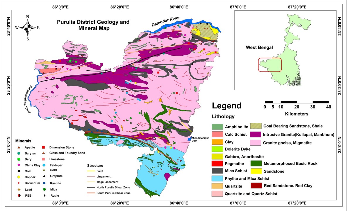
The district encompasses a variety of rock types spanning different geological ages, from the Archaean era to more recent times. These include:
·???????? The Chhotanagpur Gneissic Complex, which covers the majority of the district.
·???????? Plutonic gabbro and anorthositic rocks.
·???????? Metasedimentary and metabasic rocks of the Singhbhum Group.
·???????? The Dalma Group of basic volcanic rocks.
·???????? Intrusive granites such as Kuilapal and Manbhum granites.
·???????? Gondwana Group sedimentary rocks containing coal seams.
·???????? Quaternary sediments, with decreasing antiquity as you move down the list.
A map displays the components of these rock groups and their distribution. Notably, a mineral-rich WNW-ESE trending tectonically disturbed shear zone, known as the South Purulia Shear Zone, closely follows the boundary between the Singhbhum Group and the Gneissic Complex. Another such shear zone, the North Purulia Shear Zone (NPSZ), is found to the north, between Jhalida and Raghunathpur, and is associated with barytes, apatite-magnetite, and rare earth element (REE) mineralizations. Additionally, there are numerous lineaments of unknown tectonic significance identified through remote sensing. Slightly north of the NPSZ, there exists a parallel zone with mega-lineaments and several rare metal-bearing pegmatites.
领英推荐
Purulia district is home to a range of valuable minerals and commodities, including substantial deposits of:
·???????? Coal: (54 million tonnes, 43 Mt of high grade and 11 Mt of low grade coal)
·???????? Apatite (2090216 tonnes as on 1.4.2010)
·???????? China Clay (23.882 million tonnes)
·???????? Crystalline Limestone (17.95 million tonnes)
·???????? Copper (0.112 million tonnes)
·???????? Kyanite (26.525 tonnes)
·???????? Barytes (433 tonnes)
·???????? Dimension Stones: Including black, Spotty black, Pink streaky gneiss, Pink spotty/ribbon gneiss, and Pink porphyry granites.
·???????? Rare Metals (Cs, Li, Ab) in the Beku area.
In addition, there are smaller occurrences of minerals such as gold, graphite, beryl, corundum, rutile, fluorite, feldspar, galena, and mica. The district also has potential for construction materials and building stones.
Senior Project Associate at CSIR-Central Institute of Mining and Fuel Research, Dhanbad, India
8 个月Bibek Chatterjee Could you please share the source of this map? I would love to explore more of such valuable information.